How many of these mind-blowing Chinese landscapes do you know?
Read, share, and explore related stories through curated categories and tags.
We often say that China is a vast and resource-rich country.
From a geographical perspective,
this statement is not an exaggeration at all.
Each place has its own unique landscape,
and across the vast expanse of Chinese territory,
even similar types of scenery
take on different charms in different regions.
Today, Geo-Jun will not only take you on a tour of beautiful sights across the country
but also challenge you with a little quiz.
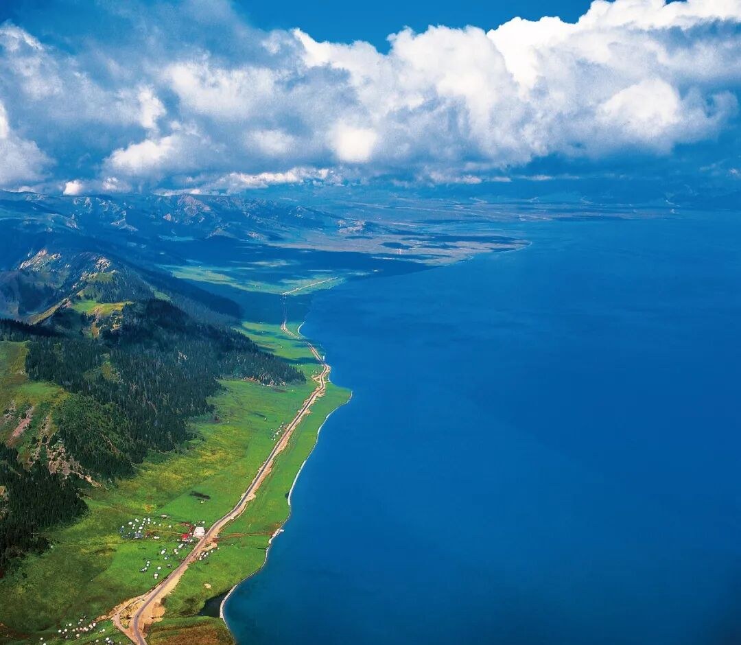
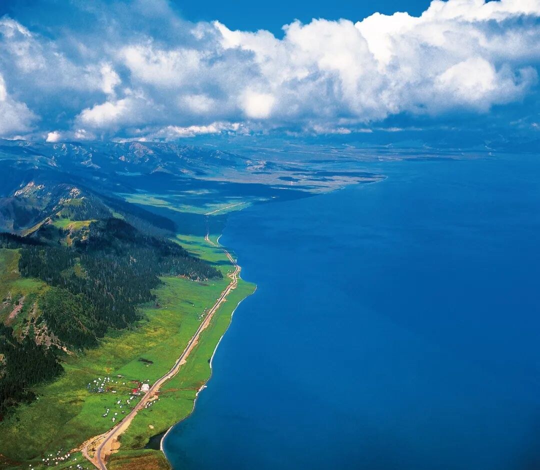
Where is this
Click to see the answer
This is the southern shore of Sayram Lake in Bortala Mongol Autonomous Prefecture, Xinjiang. Located in a highland basin on the northern slopes of the Tianshan Mountains, Sayram Lake is the highest-altitude and largest alpine cold-water lake in Xinjiang.
The Grasslands
Are Not All Endless Green Meadows
In geography, based on differences in climate and vegetation, grasslands are classified into various types, such as meadow steppe, typical steppe, desert steppe, and alpine steppe. The lives of herders in different geographic regions also vary greatly.
Many people’s concept of grassland landscapes comes from poetic depictions like “The sky is vast, the wilderness boundless, and when the wind blows, the grass bends low to reveal cattle and sheep.” From a scenic perspective, many grasslands share similar features: green grass, winding rivers, cattle and sheep, herders… Apart from their different geographic coordinates, it’s hard to pinpoint what truly sets these grasslands apart.
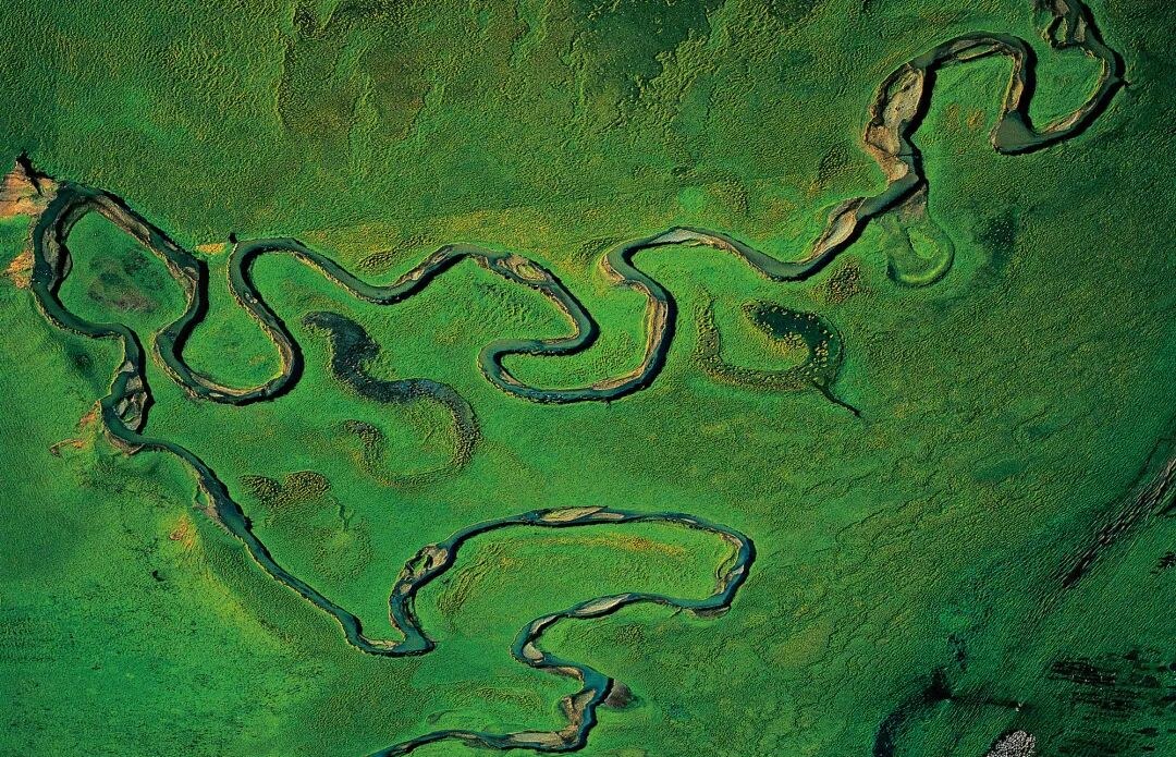
Photo from Chinese National Geography, February 2016
The Gannan grassland wetlands are a representative area of high-altitude marsh wetlands, with a large wetland coverage on the Qinghai-Tibet Plateau. From an aerial view, this region not only boasts vast grasslands but also scattered lakes of various sizes and winding river bends.
Kalajun, located in the Yili River Valley of Xinjiang, breaks the typical “fatigue” caused by the monotonous colors and single landscape of ordinary grasslands, showcasing the aesthetics of mountain grasslands represented by Kalajun. This defines a new type of grassland landscape—a “three-dimensional grassland” that blends different times and spaces with vibrant colors, and is easy to appreciate.
In Nagqu, Tibet, the poetic line “when the wind blows, the grass bends low to reveal cattle and sheep” no longer applies. Compared to the lush and mild temperate grasslands, this area has an average elevation over 3,000 meters higher, with severe cold, lack of oxygen, dry climate, and a cold, windy dry season lasting more than half the year. As a result, a unique type of grassland develops here—alpine grasslands mainly spread across the vast and flat western region, forming the most predominant grassland type. Though the howling wind is fiercer, the grass in the boundless wilderness does not bow down—because it is too short and sparse.
★ Quiz ★
Identify each of the following photos.
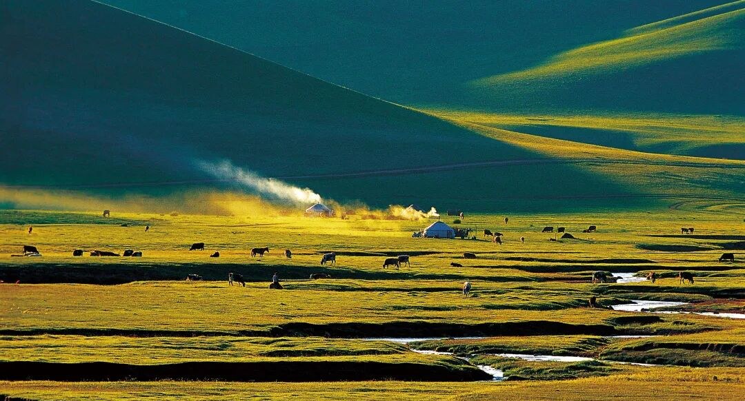
Where is this
Tap to see the answer
The autumn grasslands of Ujimqin, Xilingol, Inner Mongolia, present a unique idyllic landscape exclusive to northern China.
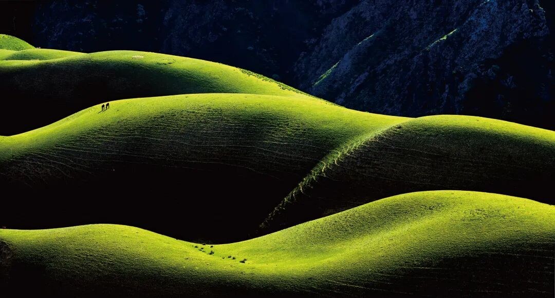
Where is this
Tap for the answer
In the western part of the Kalajun Grassland in the Yili River Valley of Xinjiang, there lies a vast, gently undulating planation surface with graceful curves, which locals call the “Human Body Grassland.” The Tianshan Mountains extensively developed three levels of planation surfaces, leveling the multi-phase tectonic structures and folded rock layers from the Paleozoic and Mesozoic eras. The Kalajun Grassland is primarily located on the third planation surface of the Tianshan. After continuous erosion by external forces, these planation surfaces have formed an undulating and gully-strewn landscape. Their elegant curves, highlighted by light and shadow, have become a favorite subject for photographers.
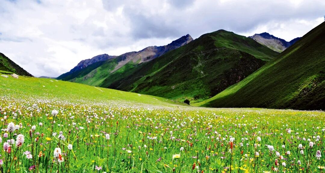
Where is this?
Tap to reveal the answer
In people’s impression, the Nagqu grassland in Tibet often appears as a vast, barren wilderness. But in reality, in some areas, you can also see lush pastures covered with flowers. In the photo, the endless pink-and-white flower sea is dominated by a plant with a cute name—“Lamb Flower.” It gets its name because its pinkish-white, round blooms resemble newborn lambs.
Lakes
Beyond Blue, How Many Colors Are There?
China’s vast territory is home to numerous lakes, found across high plateaus, mountain ranges, plains, and lowlands—whether in the humid east or the arid northwest. Even in the heart of extreme deserts, where rain is scarce year-round, lakes can still be found.
Geological forces such as crustal movements, volcanic eruptions, sedimentation, and weathering have shaped tens of thousands of lakes across the Chinese landscape. The water color of these lakes varies greatly due to differences in their natural surroundings.Image from Chinese National Geography, April 2010
The water color and transparency of Qinghai Lake are unmatched by any of the five great freshwater lakes in the eastern plains. Surrounding the lake are endless grasslands, where shepherds move with their flocks along the shore, like clouds drifting across the blue sky.
According to the Annals of Chinese Lakes, China’s lakes are divided into five major geographical regions: the Eastern Plains, the Inner Mongolia-Xinjiang Plateau, the Yunnan-Guizhou Plateau, the Qinghai-Tibet Plateau, and the Northeast Plains. Most lakes in the Eastern Plains are freshwater, concentrated mainly in the middle and lower reaches of the Yangtze River.
West Lake in Hangzhou is an inland lake formed by siltation. Its water comes primarily from natural rainfall and mountain springs. The dense vegetation of Jiangnan, the humid and rainy climate, and the surrounding three hills of folded mountain ranges all ensure that West Lake remains abundant in water.
Through the ages, the scenery of West Lake has always been so gentle and beautiful. “The shimmering water at its full fills the sunny eye; the misty mountains lend a strange charm in rain.” The power of poetry is eternal—it preserves the beauty of West Lake and holds our memories dear.Yongjin Bridge on the East Bank of West Lake
From the Zhejiang Hangzhou supplement of Chinese National Geography
Once a lake forms, it is continuously shaped by external natural factors and internal processes, evolving like a human life with its own birth, aging, illness, and death. Salt lakes are the product of a lake reaching its old age, a special type of saline lake.
In salt lakes located in open, flat terrain, a salt crust accumulates on the lakebed, acting as a mirror-like coating. The water above is just a shallow layer. When there is no wind or waves, the lake surface becomes as smooth as a mirror, creating the “sky mirror” landscape.
★ Quiz ★
**Where do the following images show?**Where is this?
Tap to see the answer
Zabuye Chaka, located in Zhongba County, Shigatse City, Tibet, has a lake shaped somewhat like a gourd, divided into northern and southern parts. The northern lake is relatively full of water, while the southern lake is a mix of solid and liquid. So, at the southern lake of Zabuye Chaka, you can see a perfect “Mirror of the Sky” landscape, and the scenery around the lake is also incredibly vast and magnificent.
Where is this?
Tap to reveal the answer
This is Jiangxi’s Poyang Lake. The formation of this vast water-town desert is related to certain sections of the Gan River and the characteristics of Poyang Lake—the typical area of Houtian Desert lies at the big bend where the Gan and Jin Rivers meet; its formation is linked to sandy terraces and sandy high floodplains being eroded by wind after vegetation was destroyed. As for the strange sand dunes by Poyang Lake, their origins are both ancient and modern.
Where is this?
Tap to see the answer
Xiechi, a massive salt lake in Yuncheng, Shanxi Province, is also known as a “rose lake.” This image shows that, when viewed from above, the lake’s surface still displays a “intoxicating” wine-red color during persistent cold weather, though the hue has become more singular compared to summer. If you visit during the hot summer, the higher salinity helps various organisms in the salt lake explode in growth, giving the water a diverse array of vibrant colors.
Canyons
A Game Between Rivers and the Land
What is a canyon? A valley with a depth greater than its width and a “V”-shaped cross-section is called a V-shaped valley, commonly known as a canyon.
This usual definition of a canyon has some flaws. Because it only describes the cross-section of the canyon, without describing its longitudinal or planar shape—for example, how to determine the length of a canyon, or where it starts and ends.
Some geographers have proposed a supplementary definition that a canyon should have “penetrability.” “Penetrability” means that both ends of the canyon are basins or open areas. This definition is very meaningful for determining the starting point and length of a canyon.The magnificent yet graceful Ni Qu River Gorge
Image from China National Geography, October 2006
The formation of a gorge depends not only on river cutting but also on the uplift of terrain—that is, the coordination of landforms. As a result, China’s gorges are mainly concentrated at the transitions between the country’s three major topographic steps. For example, at the rise from the third step to the second step, you find the Taihang Mountain Gorge, the Three Gorges, and others.
★ A Quiz for You ★
What are the following images?
(If the original text included images, their descriptions or locations would follow here.)Where is this?
Tap to see the answer
Tucked away on the northern slopes of the Tianshan Mountains in Xinjiang, the Anjihai Grand Canyon is a wonder crafted by nature’s extraordinary skill. This understated valley, known for its vibrant colors and densely layered terraces, is a breathtaking canyon that leaves you in awe.
Where is this
Tap to see the answer
After a fresh snowfall, the sky clears over Huangyagen in Huixian City, Henan. Above the towering cliff faces on both sides of the deep Taihang Mountain gorge, clouds and mist swirl, creating a scene that feels like a fairyland on earth. Straddling the second and third steps of China’s terrain, the Taihang Mountains are the range where meandering gorges (referred to as “qūxiá”) are most developed.
Where is this?
Tap to reveal the answer
The image shows the Wu Gorge. Large areas of limestone layers are distributed on both sides of the Three Gorges, and the Wu Gorge is a typical limestone canyon. Only in karst landform areas can such sharp cliffs appear, because in the karst canyon area of the Three Gorges, the soil layer is thin with little sediment. Coupled with the strong water transport of the Yangtze River, slope deposits and diluvial deposits cannot accumulate at the foot of the cliffs, making them so neat and clean.
Coastline
The Edge Where Sea and Land Vie for Dominance
The endless struggle and交融 between sea and land have shaped the coast’s soft curves and sharp angles, its rugged reefs and gentle beaches, creating natural wonders and leaving behind tales of history and legend.
As a country with a mainland coastline stretching over 18,000 kilometers, China boasts every type of coastline found on Earth—from steep, rocky shores to soft, sandy beaches, from muddy coasts teeming with seabirds to vibrant, colorful mangrove and coral reef coastlines. Simply put, if a coastline type exists in the world, you can find it here—nothing is missing.Muddy Coast - Putian, Fujian
Image from Chinese National Geography, October 2020
The harbors and tidal flats of Putian City, Fujian Province, are ideal for raising razor clams. The bays experience gentle winds and waves, smooth tidal currents, and a steady inflow of fresh freshwater year-round, creating high-quality soft mud and sandy-mud beaches that support clam growth. The photo shows Taihu Village, a traditional fishing village by Meizhou Bay in Putian, where villagers who farm razor clams are cleaning the mud during low tide.
In the past, China’s coastline was characterized by a boundary at the Yangtze River Estuary: the northern shoreline was straight, while the southern shoreline was winding. This was linked to the prevalence of plain coasts in the north and rocky coasts in the south.
Now the situation has reversed: the northern coastline has become winding, while the southern coastline has straightened out, and the differences between the two are shrinking. This is one of the findings from the research team of Hou Xiyong, a researcher at the Yantai Institute of Coastal Zone Research, Chinese Academy of Sciences.
The underlying reason for this change is the rapid increase in artificial coastlines in both the north and south, especially along the coast of the Bohai Sea. The dense distribution of ports here has not only led to issues like redundant construction and disorderly competition but also transformed originally straight shorelines into an “artificial” and “geometric” winding shape.
★ Quiz ★
Identify each of the following images****Where is this
Tap to see the answer
Luoyang Bridge is a famous historical site in Quanzhou, Fujian. Beneath this cross-sea bridge, clear blue waves once rippled. But now the sea is gone, replaced by thousands of acres of mangroves. From a scenic perspective, Luoyang Bridge above the mangroves looks like a rainbow floating on green clouds, exceptionally beautiful.
Where is this?
Tap to see the answer
On the side of the southern tip of the Liaodong Peninsula facing the Bohai Sea, in Daheishi Village, Ganjingzi District, Dalian City, there are two beaches locally known as Daheishi and Xiaoheishi. Daheishi is famous for its seaside bathing area, while nearby Xiaoheishi is a great spot to appreciate bedrock-eroded coastline. Here, not only are there sea stacks and other landscapes, but the nearshore rock reefs also take on a special form: the bedrock is etched with rows of stone grooves, where the water is clear and the sand is calm. The surface of the rock reefs has soft lines, no sharp edges, and a relatively smooth shape. The thick green seaweed covering the rocks adds a touch of softness to this coastline.
Where is this
Tap to see the answer
The picture shows an exceptionally flat and wide tidal flat in Yancheng, Jiangsu. The shallow water is calm and unruffled, like a giant mirror of the sky, blending heaven and earth into one. In the distance, a dense flock of birds, like scattered stars, marks the boundary between sky and ground, as the photographer captures this wondrous scene.
Tired of the mundane same-old scenes around you?
Why not look farther away
Otherwise, how would you know
That all those mountains, rivers, lakes, and seas
Can be so wildly different
The 13 questions above
How many did you get right
Come to the comments and compete
If you want to learn more about these places
Read the original digital edition
of China National Geographic magazine
Click the cover image to view and purchase the digital editionThe following 8 issues: Save 8 for every 88 spent.
China National Geography Magazine Digital Edition
Limited-time offer ends at
24:00 on October 31****Chinese National Geography 2006 Issue 10
-
From Greater Shanghai to Mount Everest
-
The Canyon RoadChina National Geographic, Issue 03, 2011
-
Numerous salt lakes, few rose lakes: A “romantic lake” falls from the sky**“China National Geographic” Issue 10, 2012**
-
Hulunbuir Grassland
-
Lush Lowland Oasis
-
The New Nomadic EraChina National Geography Issue 10, 2013
-
Altai Mountains
-
Tianshan Mountains
-
Junggar Basin
-
Tarim BasinChina National Geographic, Issue 10, 2020
-
Great Changes: China’s Coastal Zone
-
Rocky Coast: It Gives Beauty and Freedom—What More Could You Ask For?China National Geography, Issue 05, 2021
-
Many Salt Lakes, Few Rose Lakes: A “Romantic Lake” Dropped from the Sky**“Natural History” Issue 04, 2014**
-
“Grasslands” · “Mountains” · “Gobi""Chinese Heritage” Issue 07, 2014
-
Zhangbei, a magical grassland stronghold
-
A colorful tapestry on the prairie canvas
Want to see more digital magazine editions?
Click the image below
to enter the “China National Geography Free Reading” mini program
The classics you’ve missed can be viewed here
Don’t miss out
Editor: Xiao RongHow beautiful is China’s land, really?
Which breathtaking landscapes appear in the college entrance exam geography questions?
China’s most stunning canyons, where mountains and rivers dance together
Tag navigation
Explore articles that share the same tag and jump to tag pages.

Category navigation
Jump to the article’s category or explore nearby topics.
„Historische Städte Chinas in Jiaxing“ – ein Blickfang!
Jump to the more recent article in this topic series.
Der chinesische Verband der Landschafts- und Sehenswürdigkeitsgebiete lobt die wunderschöne Raufrostlandschaft des Berges Tai
Continue to the previous article in this series.
Related stories
More articles from the same category and nearby topics.